

In the realm of technological innovation, artificial intelligence (AI) stands as a cornerstone, revolutionizing various industries with its ability to emulate human-like intelligence in machines. At the heart of this transformative force lies deep learning, a subset of AI that mimics the workings of the human brain through artificial neural networks. Deep learning has empowered machines to process vast amounts of data, recognize patterns, and make decisions with remarkable accuracy. One of the most promising intersections of AI and real-world applications is found in Geographic Information Systems (GIS), giving rise to GeoAI. GeoAI harnesses the power of AI to analyze and derive insights from spatial data, unlocking a new dimension of possibilities in fields such as urban planning, environmental monitoring, and disaster management.
It all seems a little intimidating doesn’t it? But just like how ChatGPT has brought AI to the novice user, GeoAI tools are readily available to make maps for you, analyze imagery, or count features.
Training a deep learning model can take a lot of time and expertise. But as with most things on the internet, some do-gooders have pre-packaged deep learning models for anyone to use.
We took a deep learning model designed to plot building footprints, made absolutely no adjustments to the parameters, and put it to the test.
First we needed to install the required dependencies in our instance of ArcGIS Pro, but from that point, it was as simple as running a geoprocessing tool. We fed in an orthomosaic we had laying around, set the model to run only on our map extent (for testing purposes) and hit run. This is the result:
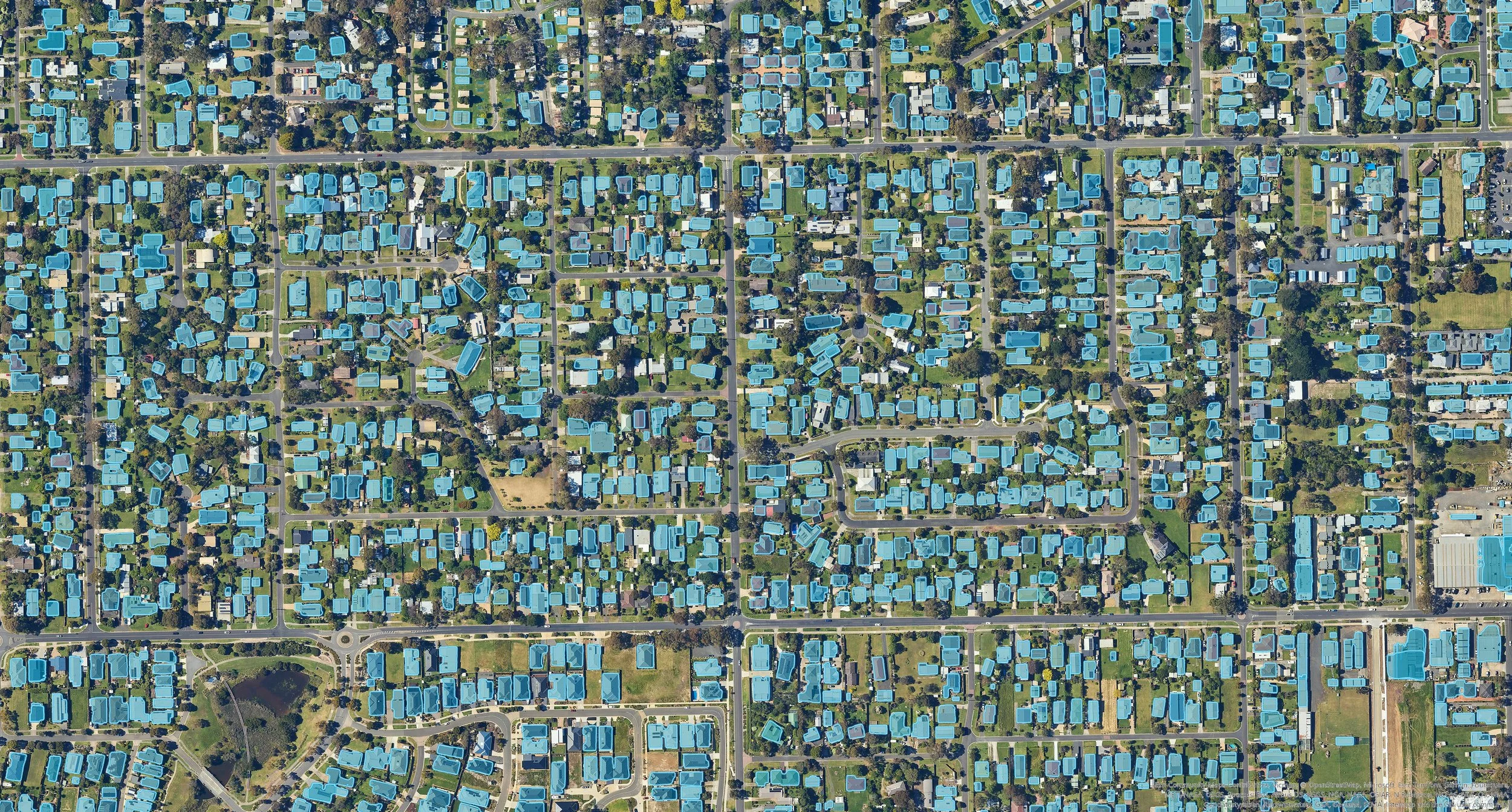
AI used to digitise building footprints from an orthomosaic.
The results are not perfect with a couple of false negatives, but it is a fantastic start. Manual cleanup would not take long at all compared to the workload it would have taken to digitise this data from the start. This is a small subset of a town, so with a larger dataset, it would turn days of digitisation work in to a 10 minute process.
Emboldened by this, we decided to test our luck with a solar panel detection workflow:

AI used to detect solar panels (pink) on houses from an orthomosaic.
Just to reiterate, these processes were run without additional training or modification. They were trained by someone else, on a different data set and simply applied to our imagery without change. If they were trained on our specific dataset, the results would have been far superior for our particular use case.
Consider what else AI can do for GIS:
Spatial Data Analysis: AI algorithms can analyze large volumes of spatial data to identify patterns, trends, and anomalies that may not be immediately apparent to human analysts.
Image Recognition and Classification: AI techniques such as convolutional neural networks (CNNs) can be used to automatically classify and analyze aerial and satellite imagery, identifying features such as buildings, roads, vegetation, and water bodies.
Object Detection and Tracking: AI algorithms can detect and track objects of interest in geospatial imagery, such as vehicles, ships, or wildlife, enabling applications in traffic monitoring, maritime surveillance, and wildlife conservation.
Land Use and Land Cover Mapping: AI can automate the process of classifying land use and land cover types from satellite imagery, providing valuable information for urban planning, agriculture, and environmental monitoring.
Natural Disaster Detection and Management: AI models can analyze real-time geospatial data to detect and predict natural disasters such as wildfires, floods, and hurricanes, facilitating early warning systems and emergency response planning.
Route Optimization: AI algorithms can optimize routes for vehicles, delivery services, and emergency responders based on factors such as traffic conditions, road closures, and weather forecasts, improving efficiency and reducing travel times.
Geospatial Predictive Modeling: AI can be used to develop predictive models for various phenomena, such as predicting urban growth, modeling environmental changes, or forecasting the spread of infectious diseases.
Geospatial Data Fusion: AI techniques can integrate data from multiple sources, including satellite imagery, aerial surveys, sensor networks, and social media, to create comprehensive and up-to-date maps for decision-making.
Automated Feature Extraction: AI algorithms can automatically extract features from geospatial data, such as building footprints, road networks, and vegetation cover, accelerating the process of map creation and updating.
Geospatial Data Quality Assessment: AI can assess the quality of geospatial data by detecting errors, inconsistencies, and inaccuracies, ensuring the reliability and integrity of GIS databases for decision-making purposes.
These are just a few examples of how AI can enhance the capabilities of GIS, offering new opportunities for analysis, prediction, and decision support in various domains.
Learn more about our geospatial consulting services here.
Contact TerraLab for more information on how AI can support your mapping needs.